How to Know the Coordinates to a GPS Receiver


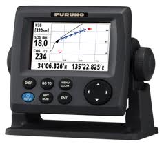
GPS navigation is very helpful in the process. We can find the coordinates of an object by using GPS. GPS replaces compass function in determining the direction of where we are heading. We do not have great difficulty when we travel. By using GPS, we can determine our position and the position of our goals.

Position data is displayed in the format of latitude and longitude. Position latitude and longitude will change when the vehicle's position also changes.

Latitude and longitude information can be displayed with various shapes, including


Decimal Degrees (WGS84)
Latitude Longitude
37.391933 -122.04375

Degrees, Minutes & Seconds
Latitude Longitude
N37 23 30 W122 02 37

GPS
Latitude Longitude
N 37 W 122 23 516 02 625

UTM
X Y
10N 584 646 4,138,781

The above data is
GPS Coordinate Converter, Maps and Info.
In general, the latitude and longitude information displayed by GPS format. These data are NMEA data obtained from satellites. To convert the format of GPS in another form, you can visit boulter and itouchmap


GPS Functionality

GPS or Global Positioning System, is a device or system that can be used to information the user where he is here on satellite-based earth's surface. To be able to identify where a person is given the tools it needs a GPS receiver which receives signals sent from GPS satellites. The position on the change becomes a point known as waypoint. Waypoint in the form of points of latitude and longitude coordinates of the position of a person or a location is then displayed on the screen on an electronic map. Data sent from the satellite in the form of radio signals with digital data. Wherever you are, then the GPS can help indicate the direction, as long as you see the sky. GPS service is available free of charge, did not even need to pay anything except buy a GPS receiver. GPS receiver module shaped and generate NMEA data containing position data. GPS receiver itself contains several integrated circuit (IC) technology is so cheap and easy to use by everyone. Examples of GPS receivers currently on the market is the Garmin 10x. GPS receiver module has the characteristics of the data can only provide information on the position but were unable to send data over long distances. Therefore, we need technology to transmit data remotely through the Internet. The technology is GPRS (General Packet Radio Service).


At present GPS is implemented on many people's lives. For example, use on aircraft, ships, cargo car. In addition, GPS can also be used for the benefit of individuals (personnal tracking systems), for example, used as vehicle tracking.
In general, the use of GPS, among others:
  1. Supports the application of GIS (Geographic Information System) includes monitoring (monitoring), tracking (tracking), pemandauan (guidance).
  2. GPS as a means of digitizing the earth.
  3. GPS function to correlate the data.
  4. GPS is an auxiliary device analysis, because the GPS uses information as a key position to analyze, make inferences, or decided.
After experiencing growth, the GPS currently widely used to meet human needs such as:
  1. Navigation system in ITS (Intelligent Transport System). This system can be implemented on a police patrol car, train, ambulance, taxi, car delivery (Courrier).
  2. As an ocean transportation navigation systems.
  3. In the world of the military, GPS is widely used in tracking the troops and equipment. In addition, GPS is widely used in the enemy's reconnaissance forces.
  4. GPS is also used in monitoring forest fires.

garmin,GPS,tracking
Garmin 10X

History of GPS

GPS was originally only used only for military purposes, but in 1980, a new GPS can be used for civilian purposes. Although GPS satellites worth hundreds of millions of dollars, but everyone can use it for free. The satellites were owned by the Ministry of Defence (the Department of Defense), the United States who first introduced starting in 1978. GPS can be used anywhere within 24 hours. The position of the GPS unit will be determined based on points of degrees of latitude and longitude coordinates. GPS satellites first launched in 1978, In the development of the GPS many more. In 1994 there were 24 satellite GPS. Now the GPS satellites that operate already more than 30 pieces. GPS satellite age average of 10 years, so when they are past 10 years, it should be routine maintenance or replacement. GPS satellite weight average 2000 ± pounds (± 1 ton), the width of the solar panel is ± 17 feet / ± 5 meters, power transmission. GPS satellites orbiting at an altitude of approximately 12,000 miles of Earth's surface. This position is ideal because the satellite can reach a wider coverage area. These satellites will always be a position that can reach all the areas above the earth's surface so as to minimize the occurrence of blank spots (areas not covered by the satellite coverage). Each satellite can circumnavigate the globe in just 12 hours. Very quickly, so that the GPS satellites can always reach your position anywhere on the earth's surface.